It is widely known that walking is beneficial to one’s health and well-being. Walking has the following advantages to our body, according to the BetterHealth channel:
- Enhanced Cardiovascular and pulmonary fitness (heart and lungs)
- A lower chance of heart disease and stroke
- Joint and muscle stiffness or discomfort, hypertension (high blood pressure), high cholesterol, and diabetes can all be better managed.
- Stronger bones and a better balance
- Improved muscle strength and endurance have improved
- A decrease in body fat
Walking has several psychological advantages in addition to physical health advantages. Based on a recent study, it has been concluded that the more people walk each day, the more energized and happier they feel.
Start walking to destinations instead of driving. This is perhaps the simplest approach to include more walking into your daily life. It is a lot easier to get your steps in if you reside in an area where the grocery store, coffee shops, parks, library, and other locations are easily accessible by walk.
Some neighborhoods in Cincinnati are significantly more walkable than others. Walk Score, a website that assesses the walkability of communities on a scale of 0-100 to represent how feasibly you can walk to adjacent facilities, can determine how different walkable neighborhoods are.
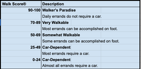
The following is how Walk Score characterizes their results:
Let’s see how walkable different Cincinnati neighborhoods are using this information.
Cincinnati’s Neighborhoods: How Walkable Are They?
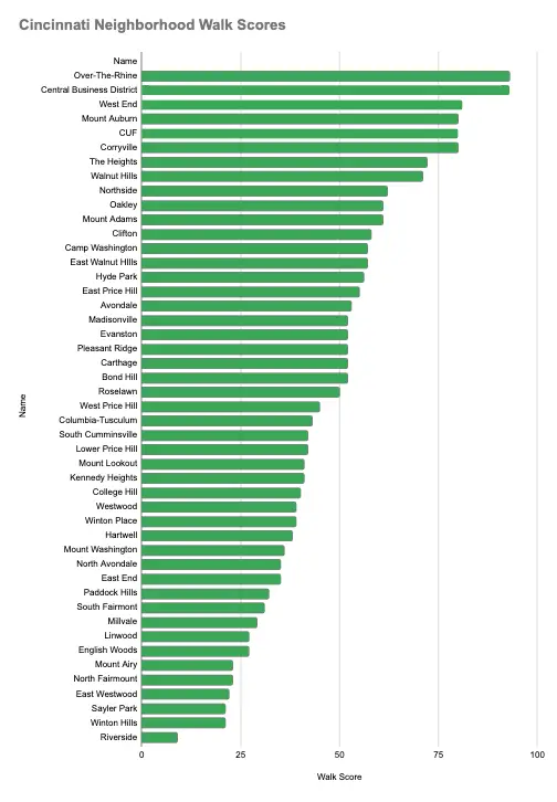
It is no surprise that the areas with the greatest walk scores are in downtown Cincinnati, but those on the city’s outskirts have lower walk scores because walking to places like grocery stores, libraries, and other services is considerably more difficult.
Outside of downtown, however, there are pockets of highly walkable neighborhoods such as Hyde Park, Oakley, and Madisonville, which are intriguing to see.
To see how walkable different areas of Cincinnati are, we may look at the Walk Scores for 47 other neighborhoods across the city:
| Rank | Name | Walk Score | Population |
| 1 | Over-The-Rhine | 93 | 6,262 |
| 2 | Central Business District | 93 | 5,586 |
| 3 | West End | 81 | 6,521 |
| 4 | Mount Auburn | 80 | 4,994 |
| 5 | CUF | 80 | 6,078 |
| 6 | Corryville | 80 | 3,370 |
| 7 | The Heights | 72 | 9,845 |
| 8 | Walnut Hills | 71 | 6,663 |
| 9 | Northside | 62 | 6,775 |
| 10 | Oakley | 61 | 10,063 |
| 11 | Mount Adams | 61 | 1,703 |
| 12 | Clifton | 58 | 9,286 |
| 13 | Camp Washington | 57 | 1,367 |
| 14 | East Walnut HIlls | 57 | 3,594 |
| 15 | Hyde Park | 56 | 12,457 |
| 16 | East Price Hill | 55 | 12,648 |
| 17 | Avondale | 53 | 7,863 |
| 18 | Madisonville | 52 | 10,630 |
| 19 | Evanston | 52 | 8,966 |
| 20 | Pleasant Ridge | 52 | 9,012 |
| 21 | Carthage | 52 | 3,470 |
| 22 | Bond Hill | 52 | 8,028 |
| 23 | Roselawn | 50 | 5,983 |
| 24 | West Price Hill | 45 | 19,504 |
| 25 | Columbia-Tusculum | 43 | 2,164 |
| 26 | South Cumminsville | 42 | 1,288 |
| 27 | Lower Price Hill | 42 | 618 |
| 28 | Mount Lookout | 41 | 6,082 |
| 29 | Kennedy Heights | 41 | 5,361 |
| 30 | College Hill | 40 | 14,237 |
| 31 | Westwood | 39 | 30,387 |
| 32 | Winton Place | 39 | 2,185 |
| 33 | Hartwell | 38 | 5,395 |
| 34 | Mount Washington | 36 | 11,559 |
| 35 | North Avondale | 35 | 6,811 |
| 36 | East End | 35 | 712 |
| 37 | Paddock Hills | 32 | 1,814 |
| 38 | South Fairmont | 31 | 3,335 |
| 39 | Millvale | 29 | 929 |
| 40 | Linwood | 27 | 963 |
| 41 | English Woods | 27 | 604 |
| 42 | Mount Airy | 23 | 8,951 |
| 43 | North Fairmount | 23 | 1,209 |
| 44 | East Westwood | 22 | 4,816 |
| 45 | Sayler Park | 21 | 3,170 |
| 46 | Winton Hills | 21 | 5,322 |
| 47 | Riverside | 9 | 1,888 |
These Walk Scores are visually represented in the chart below:

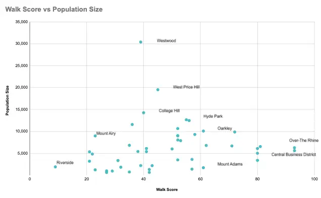
The following graph displays the walk score in relation to the size of each neighborhood’s population:
It is interesting to observe that population size and walk Score do not have much of a correlation. The size of the community does not matter while determining whether it is walkable.
Getting a Closer Look at the Highly Walkable Communities
According to Walk Score, Only eight of the 47 neighborhoods in the city qualify as “Walker’s Paradise” or “Very Walkable.”
Walker’s Paradise
A neighborhood that has a Walk Score between 90 to 100 is called a “Walker’s Paradise.”
In Cincinnati, there are just two neighborhoods that fit this criterion:
- Central Business District (93)
- Over-The-Rhine (93)
Very Walkable
A neighborhood that has a Walk Score between 70 to 89 is called a “Walker’s Paradise,” according to Walk Score.
In Cincinnati, six neighborhoods fit this criteria:
- Walnut Hills (71)
- The Heights (72)
- CUF (80)
- Corryville (80)
- Mount Auburn (80)
- West End (81)
Identifying the Most Walkable Communities
The Map below depicts the locations of the eight communities designated as a Walker’s Paradise or Very Walkable:
Conclusion
In conclusion, incorporating walking into one’s daily routine can have numerous health benefits, and walking to nearby destinations is an easy way to achieve this.
While some neighborhoods in Cincinnati are more walkable than others, there are still pockets of highly walkable areas, such as Hyde Park, Oakley, and Madisonville.
The Walk Score assessment tool provides valuable insights into the walkability of different communities, and it is clear that the size of the population does not determine walkability. Ultimately, by prioritizing walkability, individuals can enjoy a more active and healthier lifestyle while contributing to the creation of more pedestrian-friendly communities.


